Smart Projects proudly offers comprehensive marine geophysical survey services to provide accurate and reliable subsurface data essential for coastal developments, offshore construction, and environmental research. With advanced techniques such as Multi-Channel Analysis of Surface Waves (MASW), Electrical Resistivity Tomography (ERT), and Ground Penetrating Radar (GPR), we ensure every project is built on a solid foundation with minimal environmental impact.
Our team of highly skilled geophysicists and engineers leverages cutting-edge technology to generate precise subsurface profiles. Trust Smart Projects to convert complex geophysical data into actionable insights, empowering successful marine projects across the UAE’s dynamic maritime sector.

What We Offer in Marine Geophysical Survey Services?
At Smart Projects, we specialize in marine geophysical surveys that use advanced technology to map and assess seabed and subseafloor conditions. Our services support offshore construction, oil and gas exploration, environmental studies, and archaeological assessments. We are committed to delivering precise geophysical solutions tailored to your project’s requirements.
Our Marine Geophysical Survey Services in the UAE
Bathymetric Survey
We offer comprehensive bathymetric surveys using advanced echo-sounding technology to map underwater topography, ensuring precise data for safe navigation, construction, and dredging operations. Our high-resolution depth maps are essential for designing maritime structures such as ports, bridges, and pipelines.
Side Scan Sonar (SSS) Survey
Our Side Scan Sonar surveys deliver high-resolution seabed imagery, making it easy to detect objects, map seabed features, and conduct archaeological assessments. These surveys are ideal for environmental studies and debris detection in preparation for construction activities.
Seabed Imaging Survey
With seabed imaging surveys, we provide detailed visuals of seabed conditions, enabling effective planning for subsea construction projects. This service is also invaluable for marine resource exploration and environmental research.
Magnetometer (MAG) Surveys
Our magnetometer surveys identify ferrous objects and geological features by measuring variations in the Earth's magnetic field. This service is ideal for archaeological research, environmental assessments, and subsea planning.
Ocean Current Measurements
Smart Projects provides ocean current measurement services essential for designing offshore structures and maritime activities. Understanding current. patterns enables engineers to optimize the placement of wind turbines, oil platforms, and other structures.
Shallow Seismic Survey
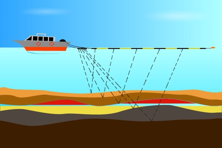
Smart Projects provides shallow seismic surveys that use energy waves to explore shallow subsurface structures. These surveys are crucial for identifying sediment layers, faults, and rock formations, ensuring a secure foundation for marine infrastructure projects like wind farms and oil platforms.
Sub-Bottom Profiling (SBP)
We offer sub-bottom profiling services that penetrate the seabed using acoustic waves to reveal geological structures. This technique supports geotechnical investigations and site selection for underwater infrastructure, ensuring risk-free project execution.
Cable & Pipeline Route Identification
We specialize in cable and pipeline route identification to find the safest and most efficient paths for subsea installations. Our services ensure clear, obstacle-free routes, reducing risks and environmental impact during construction and operation.
ROV (Remote Operating Vehicle) Surveys
Using ROVs, we conduct detailed inspections and surveys of subsea installations and structures. Our ROVs capture high-resolution visuals, offering access to hard-to-reach areas supporting construction, repair, and research activities.
Marine Electrical Resistivity Tomography (ERT)
Our Marine ERT services help analyze subsurface conditions by measuring material resistivity, crucial for detecting contamination, groundwater movement, and assessing geotechnical stability.
Techniques We Use in Marine Geophysical Surveys
We employ a range of advanced techniques to deliver precise geophysical data for marine construction, environmental research, and resource exploration.
Acoustic Techniques
- Echo Sounders (Single and Multi-Beam): Measure water depth and generate detailed seafloor maps.
- Side Scan Sonar: Create high-resolution images of seabed features.
- Sub-Bottom Profilers: Visualize subsurface layers for geotechnical assessments.
Electrical and Electromagnetic Techniques
- ERT Surveys: Assess variations in subsurface composition and stability.
- EM Surveys: Detect buried objects and mineral deposits.
Remote Sensing Techniques
- LIDAR and Satellite Imaging: Map shallow waters and coastal areas efficiently.
- Drone Imaging: Monitor shoreline changes and seabed conditions.
Environmental and Oceanographic Techniques
- ADCP and Current Meters: Monitor ocean currents and sediment transport.
- Tide Gauges and Wave Buoys: Track wave and sea-level changes.
Seismic Methods
- Seismic Reflection and Refraction: Identify geological formations and subsurface features.
- Shear Wave Velocity Analysis: Analyze soil and rock properties for structural planning.
Magnetic and Gravity Surveys
- Magnetometer Surveys: Locate pipelines, cables, and metal objects underwater.
- Gravity Surveys: Identify geological anomalies by measuring gravitational variations.
ROV and AUV-Based Techniques
- ROV Surveys: Inspect underwater structures and collect data.
- AUV Surveys: Perform autonomous missions for precise seabed mapping.
Diving and Visual Inspection
- Diving Inspections: Our professional divers inspect subsea installations.
- Underwater Photography and Videography: Capture detailed visuals for monitoring and reporting.

